
Your Expert Drone LiDAR Provider
California Drone LiDAR delivers high-accuracy LiDAR, thermal imaging, and bathymetry for the most demanding industries. Founded on innovation and fueled by speed, we provide the sophisticated data you need to move your project forward—with quote turnarounds in under 24 hours.
Specialty Services
LiDAR Mapping
Not all LiDAR is created equal. We utilize high-density sensors that penetrate dense vegetation and capture complex topography with surgical precision. By combining military-grade hardware with our custom-engineered flight protocols, we deliver "ground truth" data that off-the-shelf providers simply can’t match. When every centimeter matters, we provide the clarity your project demands.


Asset and Utility Inspections
We offer efficient and thorough drone inspection services for infrastructure, utilities, and facilities. Our team conducts detailed aerial inspections to assess assets, identify potential problems, and support maintenance and decision-making processes.


Real-time Orthomosaics
Experience the power of orthomosaic imaging with our drone services. We provide comprehensive aerial imagery solutions to capture high-resolution visuals, enabling you to produce detailed, geo-referenced maps for land surveying, agriculture, and more.
With our advanced processing and real-time data analysis, we seamlessly stitch multiple aerial images into a single, highly accurate representation of your site. Providing you with the deliverables you need. What normally can take weeks or months with traditional surveying, we can deliver the data in a matter of days.

_edited.webp)
Indoor Laser Scanning
Experience the power of terrestrial LiDAR laser scanning as a service with our team, using cutting-edge technology like the Leica RTC360 to capture highly precise 3D data both indoors and outdoors. Whether you need to scan factories, warehouses, or open-air construction sites, we deliver accurate, dense point clouds that enable efficient planning, documentation, and analysis. Our service empowers clients in construction and engineering to make data-driven decisions, streamline project timelines, reduce risks, and foster collaboration across every phase of development.

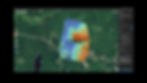
Bathymetry
We are underwater mapping experts, as well, often combining terrestrial lidar data with drone-flown sonar to create unified watershed models.
Having worked on 7 dam removal projects for fish and wildlife restoration we are excited to be adding a bathymetric lidar sensor to our suite of services in 2026. A colorized point cloud merged with the river-bed above and beneath a dam is shown below.
Custom Projects
Have a unique project in mind? Our team is equipped to handle custom drone projects tailored to your specific requirements. From environmental monitoring to emergency response, we deliver innovative solutions through drone technology.
We have invented a drone flown saw for cutting out poisonous Browntail Moth caterpillar nests from the tiptops of tall trees and a drone flown dipstick with laser altimeter to measure river bottom where flow is too fast, dangerous, aerated or turbid for echo sounding by drone or manned boat.


.png)


